Loops and Decision Tools, Case Study (Module 4 of 9)

This video case study assignment, provided by the GeoTech Center, is from module four of the Python and Geospatial Mapping course, titled Loops and Decision Tools. The course is designed for experienced users of Global Information Systems (GIS) platforms who are new to programming, with the goal of teaching them how to use Python to automate processes through the construction of short scripts in ArcGIS Pro.
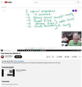
This case study simulates an assignment from a supervisor requiring learners to develop five regional geographies in a single Python script that uses at least one If, While, or For statement. Vince DiNoto, director of the GeoTech Center, explains the instructions and provides tips for completing the case study. Written instructions can be found in the Loops and Decision Tools module. Each regional geography must contain the following elements:
- A census tract feature file and a map image,
- A road feature file and a map displaying the file,
- a stream/river feature file and map,
- A county boundary feature file and map.
The video runs 3:58 minutes in length. Additional resources from the Python and Geospatial Mapping course are available to view separately.
Comments