Browse Resources
Resources |
|---|
 This paper from Wayne W. Welch of the University of Minnesota details a method for evaluating Advanced Technological Education Project and Centers. As the abstract states: "This document presents a new method to help ATE team leaders and others address their evaluation needs. It is a survey that...
 This article, which originally appeared in the International Journal of Engineering Education, describes the NSF-sponsored Southeastern University and College Coalition for Engineering Education (SUCCEED) faculty development program and briefly reviews the events in engineering education that led to...
 These resources, made available by the Center for Nanotechnology Education (Nano-Link), provide guidance for educational institutions interested in developing an undergraduate research (UGR) model. UGR is defined as "an effective tool for preparing undergraduate students for future careers," by...
 This 3-page report, written by Nora Newcombe, looks at the importance of spatial reasoning. The author makes the argument that education in the United States should focus more heavily on improving student spatial skills, as these skills are widely applicable, particularly in respect to the STEM...
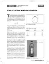 This resource, published in the Experimental Techniques journal, describes an experiment related to the Helmholz resonator. "The Helmholz resonator is perhaps the simplest acoustic resonant system. The ideal Helmholz resonator consists of an air volume enclosed with rigid walls and vented through a...
 This 7-page resource, made available by the STEM Guitar Project, is an activity "designed to lay the foundation for future discussions and learning activities regarding electric guitar pickups, and is appropriate for both middle and high school students." The learning objectives for this...
 A Process-based Analysis of Methane Exchanges Between Alaskan Terrestrial Ecosystems and the AtmosphThis paper, published by the MIT Joint Program on the
Science and Policy of Global Change, discusses how the authors used computer modeling to predict trends in the absorption and release of methane in Alaskan soils, taking into account the effects that predicted climate change might have on...
 This report from Wayne Welch of the University of Minnesota looks at the sustainability of the Advanced Technological Education Program by building on a previous survey administered to ATE Projects and Centers in 2009. As the paper states: "A survey implemented by the Evaluation Center at Western...
 In this 3-page activity, provided by the Advanced Technology Environmental and Energy Center (ATEEC), students study environmental contaminates and human health. Each student takes the role of a stakeholder in the issue of protecting a community from foodborne illness. Suggestions are provided to...
 This collection, provided by EvaluATE: Evaluation Center for Advanced Technological Education, includes two reports on a study of the use of advisory committees by ATE projects and centers. The National Science Foundation (NSF) requires National Visiting Committees (advisory committees) for all ATE...
|
| ← PreviousNext → |