Browse Resources
Information and Security Technologies -- Geospatial technologies
Resources |
|---|
 This tutorial, provided by Virginia Geospatial Extension, is part of a series of 30 videos that cover remotely sensed data in ArcMap 10.x versions. This video covers accessing and using Landsat imagery and Landsat products from ArcGIS Online. This video runs 05:56 minutes in length. The other videos...
 This tutorial, provided by Virginia Geospatial Extension, is part of a series of 30 videos that cover remotely sensed data in ArcMap 10.x versions. "This tutorial covers sub-setting Landsat Imagery." This video runs 04:19 minutes in length. The other videos in the series are available to view...
 This video, provided by Virginia Geospatial Extension, is part of a series of 28 tutorial videos on remote sensing with ArcGIS Pro. This tutorial "uses ArcGIS Pro version 2.3 to illustrate creating composites and subsets of multi-band satellite imagery." This video runs 06:08 minutes in length. The...
 This 15-page report covers best practices in student recruitment strategies for two-year community college geospatial technology programs. Contents include: General Education (GE) Course as a Major Recruitment Tool, Create Accessible and Timely Courses, and Geospatial Technology Awareness: Reaching...
 In this activity provided by the Unmanned Aircraft System operations Technician Education Program (UASTEP), students will learn to analyze multispectral images collected from a drone or unmanned aircraft system. Specifically, students will use the ArcGIS Pro software package to visualize, classify,...
 This tutorial, provided by Virginia Geospatial Extension, is part of a series of 30 videos that cover remotely sensed data in ArcMap 10.x versions. This tutorial is divided into two videos (19A and 19B) and covers "supervised classification of Landsat Imagery." During the tutorial, the following...
 This tutorial, provided by Virginia Geospatial Extension, is part of a series of 30 videos that cover remotely sensed data in ArcMap 10.x versions. This tutorial is divided into two videos (19A and 19B) and covers "supervised classification of Landsat Imagery." During the tutorial, the following...
 This video, from the Integrated Geospatial Education and Technology Training Project (iGETT), introduces the audience to the difference between supervised and unsupervised classification of remote sensing data. The lecture covers the concept of classification and its purpose before introducing the...
 This video, from the 2021 Esri Education Summit, provides presentations from three GIS professionals who share how their institution navigated the change from a desktop-centric GIS to a modern GIS, which integrates the web, desktop, mobile, and more. Best practices, positioning an institution for...
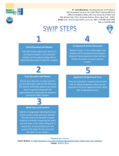 This 22-page document provides information about the application process for the Summer Workforce Internship Program (SWIP) held by the BCC Geospatial Center of the CUNY CREST Institute. The goal of the SWIP "is to train participants in industry relevant geospatial and STEM research projects."...
|
| ← PreviousNext → |